Welcome
Trimble 4D Control monitoring solution
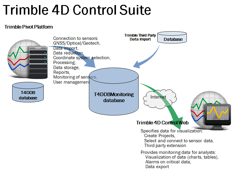
A complete Trimble 4D Control monitoring solution consists of the following components:
- Trimble 4D Control Server - The server platform that hosts the server-based processing software component of the Trimble 4D Control software suite.
- Several databases.
- Trimble 4D Control Web - The analyst UI used for sensor data configuration and for visualizing the data and issuing alarms.

Note - This documentation does not deal with the Trimble 4D Control Web software component. For more information on Trimble 4D Control Web, refer to its respective documentation.
The Trimble 4D Control Server monitoring solution
The Trimble 4D Control Server monitoring solution is a stand-alone, server-based processing software designed for engineering applications in the field of deformation monitoring.
- It steers Trimble and third-party total stations for scheduled measurements, reads-in real-time or stored measurement data and allows you to accurately determine movement over time.
- When fully licensed, Trimble 4D Control Server is also a suite of modules allowing you to monitor GNSS receivers with respect to data communication, data quality, absolute position and temporal variations of station positions. Besides the storage of raw GNSS data in various formats (among other, Trimble DAT and T01, RINEX versions 2 and 3), it includes a raw data analysis tool, which checks for outliers and cycle slips and possibly removes them from the data stream.
- In a combination of both approaches, Trimble 4D Control Server allows the integrated processing of networks combining terrestrial points and GNSS reference stations.
- When target movement is detected, in case of missing data or of position changes exceeding a user defined threshold, the Trimble 4D Control Server software generates alarms and warnings so the information can be acted on quickly.
- Trimble 4D Control Server software can be configured to accept data from a variety of geotechnical sensors.
Trimble 4D Control Server increases productivity in monitoring applications by performing the analysis of data for you. The visual tools in the software reduce rework and help catch movements faster. It also makes you more competitive by producing professional and customizable reports as the final deliverable to clients.
Along with others, Trimble 4D Control Server is designed to be used with the high-end Trimble S Series total stations (in combination with Trimble 25 mm monitoring prisms), which also store measurements in the Trimble proprietary JobXML file format using the Trimble Access or Trimble Survey Controller field software. In real-time mode, the Trimble S Series Total Station uses the Finelock™ and / or the Long Range FineLock™ mode, if the instrument supports the latter operation mode. Trimble, therefore, recommends using Trimble 4D Control Server for measuring targets with distances of greater than 20 m.
Trimble 4D Control Server features the following:
- Setup of multiple configurations for different monitoring sites
- Import and storage of GNSS reference station and terrestrial point data, including grid coordinates
- Controlling the total stations at the monitoring sites, performing reference and scheduled round measurements
- Import of total station measurements from JobXML files
- Processing of the latest total station measurements and GNSS observations, either in real time or from imported files
- Deformation monitoring over time
- Absolute position monitoring in real-time or post-processing mode based on the RTX technology
- Alarm generation
- Data storage
- Report generation
Deformation monitoring is performed by several different processing modules:
- In a real-time system, the Terrestrial Engine RT module uses the raw terrestrial measurements which all pertain to the same mission for processing to compute target point coordinates.
- A post processing Terrestrial Engine module is used to first import total station measurements from files and to set up a network of measured points before it processes these raw measurements. Additionally, it stores the raw measurements available in the central database.
- A module for post-processing GNSS data by using, for example, DAT, T01, T02, TGD, or RINEX files as input providing solutions for short baselines up to baselines of more than 1000 km.
- The Trimble RTK Engine providing fixed solutions on baselines of up to 35 km.
- The Trimble RTX Engine and RTX-PP Engine perform absolute position estimation and provide integrity monitoring for GNSS station coordinates using the Trimble RTX technology.
- An Integrated Survey Engine module processes, in an integrated approach, total station measurements of a mission in combination with GNSS data received from a GNSS Engine, such as the Postprocessing Engine or the RTK Engine.
This documentation
Even if you have used other Global Navigation Satellite Systems (GNSS) products before, Trimble recommends that you spend some time reading this documentation to learn about the special features of this product.
If you are not familiar with GNSS, visit Trimble’s website () for an interactive look at Trimble and GNSS.
This documentation cannot replace the pre-system-integration work. Trimble recommends that system integration is performed by Trimble Advanced Positioning support staff. System integration includes verification and analysis of the communication links, orbit polling, and Trimble 4D Control Server configuration as well as an additional administrator training for this Trimble 4D Control Server software package.
Note - The software described herein belongs to a family of modular Trimble software features supported by Trimble 4D Control Server. This documentation may contain the description of features, which may not be subject of your Trimble 4D Control Server installation.
This publication assumes that you know how to use the Microsoft® Windows® operating system.
